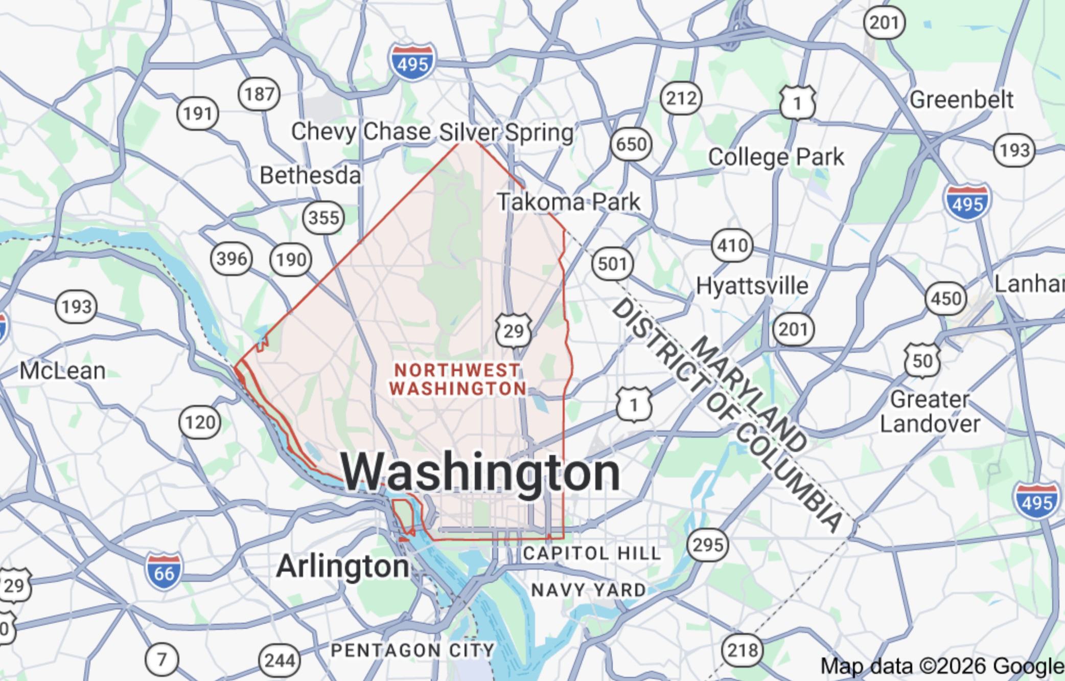
Where IS Northwest DC?
Washington DC is divided into four quadrants, using the U.S. Capitol building as the center point.
- Southwest (SW) is very small, cut off largely by the National Mall and rivers.
- Southeast (SE) and Northeast (NE) split the eastern half.
- Northwest (NW) takes up the entire upper left chunk of the diamond.
Because Northwest DC spans all the way from the downtown core to the suburban Maryland border, its real estate and lifestyle characteristics vary wildly. It houses the city's commercial business district, its most famous historic landmarks, and massive swaths of residential green space
The biggest psychological divide within the Northwest quadrant itself is Rock Creek Park, which runs right down the middle of it. When locals talk about NW, they almost always clarify which side of the park they mean:
- West of the Park (Upper NW): The quiet, leafy, highly residential neighborhoods (Woodley Park, Cleveland Park,F Chevy Chase, Tenleytown). Abbreviated as WOTP.
- East of the Park (Mid-City / Upper Center): The high-energy, rowhouse-heavy, urban neighborhoods (Columbia Heights, Mount Pleasant, Petworth). Abbreviated as EOTP.
1. Upper Northwest (WOTP)
- The Vibe: Leafy, quiet, residential, and green.
- The Landscape: Wide avenues, deep-set yards, and a peaceful, village-like rhythm. Housing consists of grand detached single-family homes, historic Victorians, and stately mid-rise apartment buildings.
- Key Neighborhoods: Woodley Park, Cleveland Park, Chevy Chase, Tenleytown, Spring Valley, and The Palisades.
- Core Boundaries: Upper NW is bounded by Western Avenue to the north (the Maryland line), the Potomac River to the west, Whitehaven Parkway to the south, and the natural valley of Rock Creek Park to the east. Within this perimeter sits a complex tapestry of 21 distinct neighborhoods, historic enclaves, and micro-subdivisions.
A. Upper NW DC: Commuter Corridors (Along the Red Line)
These neighborhoods run vertically up the spine of Connecticut and Wisconsin Avenues, offering direct Metro access.
WOODLEY PARK
- Known For: The National Zoo, direct Rock Creek Park access, historic Art Deco architecture, and the Taft and Duke Ellington bridges.
- Who Lives Here? Professionals, diplomats, and families seeking a quiet urban environment, alongside graduate students and university faculty. Woodley Park is best for renters and buyers prioritizing a leafy, historic neighborhood near beautiful parks and with a fast Metro commute.
- Core Boundaries: Rock Creek Park to the north and east, Klingle Road to the northwest, Whitehaven Parkway to the south, and 29th Street NW/Cortland Place to the west. Runs along the Connecticut Ave corridor.
CLEVELAND PARK
- Known For: Historic streetcar suburb layout, Tregaron Conservancy, large Queen Anne/Victorian homes with wraparound porches, and the 1936 Art Deco Uptown Theater building (reimagined as an immersive arts venue).
- Who Lives Here? Established professionals, academics, families tied to top-tier schools, and young professionals renting in historic low-rise apartments. Cleveland Park is best for buyers and renters seeking a peaceful village vibe with spacious historic homes and top-rated schools.
- Core Boundaries: Rodman/Tilden Streets (north), Rock Creek Park (east), Klingle/Woodley Roads (south), and Wisconsin/Idaho Avenues (west). Runs along the Connecticut Ave corridor.
NORTH CLEVELAND PARK
- Known For: Extreme residential quiet, hosting over a dozen international embassies (including Austria and Singapore), and the main Van Ness campus of the University of the District of Columbia (UDC). Often generalized by locals as "Van Ness."
- Who Lives Here? Families, diplomats, and university professors seeking low-traffic streets, alongside UDC students and professionals renting in perimeter apartments. North Cleveland Park is best for renters and buyers seeking complete neighborhood tranquility within an easy walk of two different Metro stations.
- Core Boundaries: Albemarle Street (north), Rodman/Quebec Streets (south), Wisconsin/Nebraska Avenues (west), and Connecticut Avenue (east). Sits between the Van Ness and Tenleytown Metro hubs.
VAN NESS (Often generalized as part of Forest Hills)
- Known For: The Van Ness-UDC Metro hub, high-density mid-century modern apartment towers, the University of the District of Columbia (UDC) main campus, and the newly reopened Soapstone Valley Park trail system (fully restored in May 2026).
- Who Lives Here? Metro commuters, UDC students and faculty, international diplomats, and downsizers looking for low-maintenance condo living. Van Ness is best for renters and buyers seeking an incredibly accessible transit hub with relatively affordable high-rise living right against nature trails.
- Core Boundaries: Bounded by Nebraska Avenue to the north, Tilden Street to the south, Rock Creek Park/Soapstone Valley to the east, and Reno Road to the west. Functions as the dense commercial spine of the central Connecticut Ave corridor.
FOREST HILLS
- Known For: A protected "Tree and Slope" canopy layout, the historic 25-acre Hillwood Estate, Museum & Gardens, hidden modern architectural gems mixed with grand estates, and international ambassador residences.
- Who Lives Here? Diplomats, lobbyists, high-ranking federal officials, and long-tenured professionals who value privacy and estate-sized lots. Forest Hills is best for luxury buyers prioritizing complete, suburban-style seclusion and top-tier public school zones while remaining close to the city center.
- Core Boundaries: Bounded by Broad Branch Road and Nebraska Avenue to the north, Rock Creek Park to the east, Tilden and Van Ness Streets to the south, and Connecticut Avenue to the west. Runs along the Connecticut Ave corridor.
TENLEYTOWN
- Known For: Being the highest natural elevation in DC, Fort Reno Park (featuring historic Civil War fort grounds and summer concerts), a landmark cluster of city broadcasting towers, and its historic roots as an 18th-century crossroads village.
- Who Lives Here? Families, long-time residents, and a large population of American University students and faculty. Tenleytown is best for buyers and renters wanting a bustling, collegiate "main street" environment with great public parks, modern grocery conveniences, and direct Metro access.
- Core Boundaries: Upton Street (south), Garrison Street (north), Reno Road/37th Street (east), and 42nd/43rd Streets (west). Runs along the Wisconsin Ave corridor.
FRIENDSHIP HEIGHTS
- Known For: A cross-jurisdictional footprint straddling the Maryland border, a major regional transit/Red Line Metro hub, extensive medical and wellness offices, and a dense concentration of high-end grocery and daily retail options.
- Who Lives Here? Downsizers and retirees enjoying low-maintenance condo life, alongside a steady influx of young professionals renting in the corridor's luxury high-rises. Friendship Heights is best for buyers and renters wanting a dense, highly walkable transit hub with immediate access to grocery conveniences, retail, and medical care.
- Core Boundaries: Western Avenue/Maryland line (north), Garrison Street (south), Reno Road/41st Street (east), and River Road (west). Anchors the northernmost tip of the Wisconsin Ave corridor.
B. Upper NW DC: Residential & Academic Mainstays
These neighborhoods lack a direct Metro rail station but offer highly walkable, community-centric environments centered around independent shopping strips, local schools, and public parks.
CHEVY CHASE (DC)
- Known For: A distinct "suburb-in-the-city" layout, the historic 1923 Avalon Theatre, Chevy Chase Circle, an independent retail strip along "The Avenue" (Connecticut Ave), and the massive Chevy Chase Civic Site mixed-use library/recreation redevelopment project.
- Who Lives Here? Politically engaged professionals, high-ranking federal workers, academics, and families highly drawn to top-tier public elementary schools like Lafayette and Murch. Chevy Chase is best for buyers and renters looking for a prestigious, tight-knit community with spacious single-family lawns, elite public schools, and a small-town main street feel.
- Core Boundaries: Western Avenue/Maryland line (north), Broad Branch Road (south), Rock Creek Park (east), and Reno Road/37th Street (west). Runs along the Connecticut Ave corridor.
GLOVER PARK
- Known For: A porch-front rowhouse streetscape, bordering the heavy wilderness trails of Glover-Archbold Park, community victory gardens, and daily military bugle calls from the adjacent U.S. Naval Observatory.
- Who Lives Here? Young families, military/federal officials, and graduate students who trade direct Metro rail access for a safe, low-traffic neighborhood vibe. Glover Park is best for buyers and renters seeking a self-contained, community-oriented "village" with top-tier schools and an ultra-convenient grocery/retail strip.
- Core Boundaries: Fulton Street (north), Whitehaven Park (south), Wisconsin Avenue/Naval Observatory (east), and Glover-Archbold Park (west). Sits entirely off-metro, just north of Georgetown.
CATHEDRAL HEIGHTS
- Known For: The towering Gothic architecture of the Washington National Cathedral (and its 59 acres of public grounds), the Cathedral Commons retail strip, landmark mid-century co-ops (like The Westchester and The Colonnade), and its cooler, elevated natural topography.
- Who Lives Here? Diplomats, think-tank and federal professionals, empty nesters, and families utilizing premier public and private school clusters. Cathedral Heights is best for buyers and renters who prioritize spacious urban lots, stately architecture, and neighborhood quiet over direct Metrorail proximity.
- Core Boundaries: Cathedral Avenue (north), Fulton Street (south), Wisconsin Avenue (east), and Idaho Avenue/Glover-Archbold Park (west). Sits immediately off-metro along the western edge of the Cleveland Park corridor.
AMERICAN UNIVERSITY PARK (AU PARK)
- Known For: Manicured 1930s brick Colonials, complete lack of commercial zoning, and "Turtle Park" (Friendship Park)—the community's social hub. Despite its name, American University’s main campus sits outside neighborhood boundaries.
- Who Lives Here? Upper-middle-class families, professionals, and academics. AU Park is best for single-family buyers prioritizing quiet tree-lined streets, tight community bonds, and top-tier public elementary schools within walking distance to Metro transit.
- Core Boundaries: Western Avenue/Maryland line (north), Massachusetts Avenue (south), Wisconsin Avenue (east), and Nebraska Avenue (west). Tucked between Tenleytown, Friendship Heights, and Spring Valley.
MCLEAN GARDENS
- Known For: Park-like 1942 garden-apartment layout (built for WWII defense workers), historic Ballroom, Newark Street Park access (massive community garden/dog park), and adjacency to City Ridge (home to DC's first Wegmans).
- Who Lives Here? Young professionals, families, and retirees renting or owning in dense, low-rise brick condo clusters. McLean Gardens is best for buyers and renters wanting a secure, park-like enclave with ample green space within walking distance to upscale retail.
- Core Boundaries: Rodman Street (north), Idaho Avenue (south), Wisconsin Avenue (east), and 39th Street/Glover-Archbold Park (west). Sits along the central Wisconsin Ave corridor between Tenleytown and Cathedral Heights.
C. Upper NW DC: The Exclusive & Wooded Enclaves
These are ultra-affluent, heavily canopied residential neighborhoods running toward the Potomac River. They feature large lots, custom architecture, winding streets, and minimal traffic; a car is typically required here.
SPRING VALLEY
- Known For: Winding, tree-lined topography, massive multi-million dollar estates (Georgian, Tudor, brick Colonial manors), the main campus of American University, and the neighborhood-favorite Wagshal’s Deli.
- Who Lives Here? High-ranking political figures, corporate executives, diplomats, and affluent families. Spring Valley is best for luxury buyers seeking elite, estate-sized privacy and sprawling lots, who rely primarily on vehicle travel over public transit.
- Core Boundaries: Massachusetts Avenue (northeast), Dalecarlia Parkway (west), and Nebraska Avenue/Loughboro Road (south). It occupies the westernmost pocket of Upper NW along the Maryland border.
WESLEY HEIGHTS
- Known For: Being one of America's first master-planned communities (1920s), strict historic architectural preservation overlays, lush tree canopies, and direct access to Battery-Kemble Park.
- Who Lives Here? High-profile federal officials, diplomats, and executives seeking suburban-style estate privacy. Wesley Heights is best for luxury single-family buyers and high-end condo seekers prioritizing security, historic architecture, and deep nature trails over public transit access.
- Core Boundaries: Nebraska Avenue (north), Glover Parkway (south), New Mexico Avenue/Massachusetts Avenue (east), and Battery-Kemble Park (west). Tucked directly into the Foxhall Corridor south of Spring Valley.
THE PALISADES
- Known For: A relaxed, small-town "river community" feel, the historic annual July 4th Parade, the year-round Sunday Farmers Market, and instant access to the C&O Canal and Capital Crescent trails.
- Who Lives Here? Families, outdoor enthusiasts, federal professionals, and long-time residents who value space and a quiet rhythm. The Palisades is best for buyers and renters prioritizing detached single-family yards, nature access, and top-tier public schools, who accept being car-dependent and entirely off the Metro rail network.
- Core Boundaries: Maryland line (north), Foxhall Road (south), MacArthur Boulevard/Potomac River (west), and Arizona Avenue/Glover-Archbold Park (east). Runs parallel to the Potomac River along the far western edge of Upper NW.
FOXHALL
- Known For: Winding, heavily wooded roads entirely free of commercial zoning, featuring two distinct architectural halves: the historic, uniform Tudor rowhouses of Foxhall Village and the sprawling, detached mid-century estates of Foxhall Crescents.
- Who Lives Here? University administrators, prominent federal officials, diplomats, and families seeking absolute neighborhood quiet with zero cut-through traffic. Foxhall is best for luxury buyers prioritizing estate-sized privacy, historic architectural cohesion, and premium school districts who are comfortable with a driving-dependent lifestyle.
- Core Boundaries: Reservoir Road (north), P Street/Georgetown border (south), Foxhall Road (west), and Glover-Archbold Park (east). Tucked directly between Georgetown and the Palisades.
BERKLEY (FOXHALL CRESCENTS / PHILLIPS PARK)
- Known For: Natural isolation bounded by parkland on three sides, the landmark German Embassy, George Washington University's Mount Vernon campus, and upscale architectural pockets including the tiered limestone townhomes of Foxhall Crescents and custom mega-mansions of Phillips Park.
- Who Lives Here? Diplomats, high-ranking university officials, executives, and high-net-worth families prioritizing secure enclave living. Berkley is best for luxury buyers wanting total suburban quiet, massive square footage, and zero commercial footprint while remaining driving-dependent.
- Core Boundaries: Wesley Heights Park (north), MacArthur Boulevard (southwest), Battery Kemble Park (west), and 44th Street/Foxhall Road (east). Tucked cleanly between Foxhall, the Palisades, and Wesley Heights.
KENT
- Known For: A non-commercial triangular enclave featuring 1930s/40s Colonial Revivals on estate-sized lots, alongside an eastern ridge with custom modernist homes and 18th-century farmhouses.
- Who Lives Here? High-ranking federal officials, executives, diplomats, and long-tenured families. Kent is best for luxury buyers wanting total suburban quiet and premium public school zones who prefer driving over Metro rail proximity.
- Core Boundaries: Loughboro Road (north), MacArthur Boulevard (southwest), and Chain Bridge Road/Battery Kemble Park (southeast). Tucked between the Palisades, Spring Valley, and Wesley Heights.
MASSACHUSETTS AVENUE HEIGHTS
- Known For: Winding hillside streets, multi-million dollar trophy estates, heavy embassy density, and direct adjacency to the Washington National Cathedral and the U.S. Naval Observatory.
- Who Lives Here? Ambassadors, corporate executives, and cabinet secretaries seeking hidden privacy. Mass Ave Heights is best for ultra-luxury buyers prioritizing estate-scale security, sprawling hidden lots, and architectural prestige minutes from downtown.
- Core Boundaries: Woodley Road (north), Massachusetts Avenue (southwest), 34th Street (east), and Wisconsin Avenue (west). Tucked between Woodley Park, Cleveland Park, and Cathedral Heights.
D. Upper NW DC: "Micro-Neighborhood" Subdivisions
These are tiny, strictly residential pockets touching the northern Maryland border. While often lumped in with Chevy Chase by outsiders, local real estate maps and long-time residents identify them specifically by name.
- Barnaby Woods: An affluent residential pocket built directly into the thick trees of northern Rock Creek Park.
- Hawthorne: A quiet neighborhood of stone and brick single-family homes completely isolated from urban city noise.
- Colonial Village: Located at the absolute northern tip of the DC diamond, featuring historically preserved colonial stone homes backing up directly to park wilderness.
2. Mid-City / Upper 16th Street Corridor
- The Vibe: High-energy, hyper-walkable, multicultural, and dense.
- The Landscape: Buzzing commercial avenues transitioning sharply into quiet residential grids. Streets are packed with uniform brick Wardman rowhouses, distinctive covered front porches, grand Gilded Age apartment buildings, hidden alley parks, and prominent nightlife/dining corridors.
- Key Neighborhoods: Columbia Heights, Adams Morgan, Mount Pleasant, Bloomingdale, LeDroit Park, Eckington, Park View, Pleasant Plains, and Truxton Circle (Bates).
- Core Boundaries: Mid-City is bounded by Spring Road and Rock Creek Church Road to the north, the CSX rail corridor/Metropolitan Branch Trail to the east, Florida Avenue and U Street to the south, and the natural boundary of Rock Creek Park to the west. Located entirely East of the Park (EOTP), this tight 3.1-square-mile perimeter marks the absolute geographic, populous, and transit-dense heart of Washington, DC.
A. The Core Mid-City Hubs
These are the ultra-dense, amenity-rich anchor neighborhoods along the Green/Yellow Metro line and the major 14th/16th/Georgia Avenue transit corridors.
COLUMBIA HEIGHTS
- Known For: High-density urban energy, a massive commercial retail hub (DC USA complex), striking Spanish Baroque-style architecture along 16th Street, and the historic Tivoli Theatre. It features a vibrant mix of historic grand apartment buildings, uniform Wardman rowhouses, and diverse global dining.
- Who Lives Here? A highly diverse mix of young professionals, long-time community residents, students, and families. Columbia Heights is best for buyers and renters prioritizing hyper-walkability, instant Metro rail access, and an active, bustling nightlife scene right outside their door.
- Core Boundaries: Spring Road (north), Florida Avenue (south), Georgia Avenue (east), and 16th Street (west). Centrally located on the Green Line Metro directly between Mount Pleasant, Petworth, and the U Street Corridor.
ADAMS MORGAN
- Known For: Historic bohemian spirit, a vibrant global dining and legendary nightlife hub along the 18th Street corridor, independent bookstores, and colorful, brightly painted Victorian and Beaux-Arts rowhouses. Its name historicizes the 1950s integration of the local Adams and Morgan elementary schools.
- Who Lives Here? Creatives, young professionals, diplomats, and long-time activists. Adams Morgan is best for buyers and renters prioritizing hyper-walkable independent retail, an energetic nightlife scene, and architectural character over immediate, dedicated Metrorail access.
- Core Boundaries: Harvard Street/Rock Creek Park (north), Florida Avenue (south), 16th Street (east), and Connecticut Avenue/Duke Ellington Bridge (west). It serves as a central EOTP hub bordering Dupont Circle, Woodley Park, and Columbia Heights.
MOUNT PLEASANT
- Known For: A distinct, tight-knit "village in the city" feel, classic early 20th-century front-porch rowhouses, a four-block tree-lined independent retail corridor along Mount Pleasant Street, and deep historical roots as DC's foundational Salvadoran and Latino cultural heart.
- Who Lives Here? A dedicated mix of long-time neighborhood advocates, families, young professionals, and former Peace Corps/NGO workers. Mount Pleasant is best for buyers and renters prioritizing a community-oriented, historic enclave with immediate access to Rock Creek Park trails while accepting a 10-minute walk to the Metro.
- Core Boundaries: Piney Branch Parkway/Rock Creek Park (north/west), Harvard Street (south), and 16th Street (east). Perched quietly above Adams Morgan and directly west of Columbia Heights.
B. Mid City: Historic "LeDroit-Bloomingdale" Cluster
These neighborhoods sit on the eastern edge of the Mid-City planning map. They are visually stunning, heavily historic, and share a distinct community vibe focused on front porches, basement bars, and local cafes.
BLOOMINGDALE
- Known For: Cohesive architectural charm featuring iconic, turreted Victorian rowhouses, hidden green spaces like the community-managed Crispus Attucks Park, and a hyper-local, award-winning dining pocket centered on 1st Street and Rhode Island Avenue (home to Red Hen, Boundary Stone, and Big Bear Cafe).
- Who Lives Here? A diverse mix of long-time residents, educated urban professionals, and academics. Bloomingdale is best for buyers and renters prioritizing tight-knit community networks, historic front-porch aesthetics, and neighborhood-centric dining strips while accepting a 10-to-15-minute walk to the nearest Metro.
- Core Boundaries: Channing Street (north), Florida Avenue (south), North Capitol Street (east), and 2nd Street (west). Tucked quietly on the eastern edge of the Mid-City corridor directly between LeDroit Park, Eckington, and Shaw.
LEDROIT PARK
- Known For: A distinct "suburb in the city" feel founded in 1873. It is highly celebrated for its protected historic architecture—specifically 50 surviving, non-identical Gothic cottages and Italianate villas designed by James McGill. A historic haven for the 20th-century African-American intellectual elite.
- Who Lives Here? Howard University professors, graduate students, civil servants, and historic preservationists. LeDroit Park is best for buyers and renters prioritizing peaceful residential blocks, singular historic home architecture, and deep cultural heritage while remaining steps from Shaw's commercial corridors.
- Core Boundaries: Elm Street/Bryant Street (north), Florida Avenue/Rhode Island Avenue (south), 2nd Street (east), and Georgia Avenue/Howard University (west). It sits directly below Howard's campus, immediately west of Bloomingdale.
ECKINGTON
- Known For: Pastel and brick Victorian rowhouses, distinct industrial roots, the Metropolitan Branch Trail (MBT), and Eckington Yards (a major mixed-use hub featuring a climbing gym and local maker spaces).
- Who Lives Here? Tech and creative professionals, young families, and long-term residents. Eckington is best for buyers and renters wanting a historic porch-front community with instant bike trail and modern retail access, while accepting a brief walk to the Metro.
- Core Boundaries: Rhode Island Avenue (north), Florida Avenue (south), Red Line tracks (east), and North Capitol Street (west). Located in NE (Ward 5), sitting directly east of Bloomingdale.
TRUXTON CIRCLE (BATES)
- Known For: Classic flat-front brick rowhouses, a fast-evolving local restaurant scene, and Dunbar High School—the nation’s first public high school for Black students. The namesake "Bates" refers directly to its interior historic street grid.
- Who Lives Here? Young professionals, Howard University graduate students, and multi-generational families. Truxton Circle is best for buyers and renters seeking a lower price point than neighboring Shaw, featuring historic neighborhood grit and walkable access to downtown.
- Core Boundaries: New York Avenue (north), K Street (south), North Capitol Street (east), and 7th Street (west). It acts as a southern EOTP gateway bridging Shaw, Bloomingdale, and NoMa.
C. Mid City: Georgia Avenue & University Corridors
These neighborhoods line the eastern spine of Mid-City and are deeply anchored by historic institutions and classic rowhouse streetscapes.
PARK VIEW
- Known For: Continuous porch-front brick rowhouses, a highly active tavern and dining strip along lower Georgia Avenue, and its historical namesake: direct views into the sprawling grounds of the Armed Forces Retirement Home.
- Who Lives Here? Young professionals, Howard University affiliates, and multi-generational families. Park View is best for buyers and renters wanting a residentially focused neighborhood with strong architectural cohesion, missing the intense retail crowds of Columbia Heights while remaining walkable to the Metro.
- Core Boundaries: Rock Creek Church Road (north), Gresham Place/Columbia Road (south), Park Place/Soldiers' Home (east), and Georgia Avenue (west). Tucked cleanly between Petworth, Columbia Heights, and Pleasant Plains.
PLEASANT PLAINS
- Known For: Being the residential fabric completely interwoven with Howard University and Howard University Hospital. It features classic brick Wardman rowhouses and a culturally rich history as a historic hub for Black academics and professionals.
- Who Lives Here? Howard University students, faculty, healthcare staff, and long-time families. Pleasant Plains is best for buyers and renters prioritizing high-energy campus proximity, deep cultural roots, and easy access to university and hospital networks.
- Core Boundaries: Harvard Street (north), Florida Avenue (south), 4th Street/McMillan Reservoir (east), and Georgia Avenue (west). Tucked cleanly between Columbia Heights, Park View, and LeDroit Park.
SHAW / U STREET CORRIDOR (NORTHERN EDGE)
- Known For: "Black Broadway" entertainment heritage, vibrant 14th and U Street nightlife, Michelin-starred dining, historic alleys (Blagden Alley), and live music icons like the Lincoln and Howard Theatres. The northern edge transitions from dense commercial blocks into quiet Victorian rowhouse streetscapes.
- Who Lives Here? Young professionals, creatives, and long-time residents. This area is best for buyers and renters prioritizing immediate access to premier dining, nightlife, and dual Metrorail stations while embracing a high-energy urban core.
- Core Boundaries: Florida Avenue (north), S Street (south), 7th Street (east), and 15th Street (west). It serves as the upper border of the Greater Shaw/U Street area, directly meeting Columbia Heights and Adams Morgan.
3. The Downtown & Central NW Core
- The Vibe: Fast-paced, corporate, prestigious, and highly secured.
- The Landscape: Dense commercial blocks dominated by sleek glass office towers, grand luxury hotels, power-dining restaurants, and historic public squares. The traditional 9-to-5 concrete footprint is evolving rapidly through ambitious office-to-residential high-rise conversions and activated pedestrian plazas.
- Key Neighborhoods: Downtown (Central Business District), Golden Triangle, Penn Quarter, and Chinatown.
- Core Boundaries: The Downtown/Golden Triangle core is bounded by Massachusetts Avenue and S Street to the north, 5th Street to the east, Pennsylvania Avenue and the White House perimeter to the south, and 21st Street to the west. This powerhouse zone marks the federal, commercial, and financial epicenter of Washington, DC.
DUPONT CIRCLE
- Known For: A vibrant central fountain park, grand Gilded Age mansions, Embassy Row prestige, a historic LGBTQ+ cultural legacy, independent bookstores, and diverse sidewalk dining.
- Who Lives Here? Diplomats, professionals, academics, and long-time urbanites. Dupont Circle is best for buyers and renters prioritizing hyper-walkable cosmopolitan living, historic brownstones, and instant Red Line Metro access.
- Core Boundaries: S Street (north), M Street (south), 15th Street (east), and 22nd Street/Rock Creek Park (west). Positioned between Logan Circle, Adams Morgan, Georgetown, and Downtown.
LOGAN CIRCLE
- Known For: The city's only completely residential traffic circle, magnificent late 19th-century Victorian and Romanesque mansions, and the ultra-trendy 14th Street commercial corridor. It features premier interior design showrooms, independent theaters (Studio Theatre), and high-profile dining.
- Who Lives Here? Affluent professionals, design enthusiasts, foodies, and urbanites. Logan Circle is best for buyers and renters prioritizing top-tier culinary access, a polished streetscape, and a vibrant arts scene, while comfortably accepting a 10-minute walk to the Metro.
- Core Boundaries: T Street (north), M Street (south), 12th Street (east), and 16th Street (west). It serves as a central anchor directly bordered by Dupont Circle, Shaw, Downtown, and the U Street Corridor.
GEORGETOWN
- Known For: Being DC's oldest historic district (predating the city itself), famous for cobblestone streets, the C&O Canal, luxury retail at the M Street and Wisconsin Avenue intersection, waterfront dining at Washington Harbour, and the Gothic spires of Georgetown University.
- Who Lives Here? Politicians, diplomats, corporate executives, elite university students, and affluent multigenerational families. Georgetown is best for buyers and renters prioritizing global prestige, strict historic preservation charm, and high-end retail while completely bypassing Metrorail access.
- Core Boundaries: Whitehaven Street/Dumbarton Oaks (north), Potomac River (south), Rock Creek Park (east), and 37th Street/Georgetown University (west). Bordered directly by Foggy Bottom, Burleith, and the Key Bridge connection to Virginia.
FOGGY BOTTOM
- Known For: A distinct student-and-diplomat energy driven by the sprawling George Washington University urban campus, the U.S. State Department headquarters, and the iconic Watergate complex. It features world-class arts at the Kennedy Center, hidden historic alleys (Snows Court), and riverside paths.
- Who Lives Here? Undergraduate and graduate students, university faculty, federal employees, and international diplomats. Foggy Bottom is best for buyers and renters prioritizing unparalleled proximity to global institutions, riverside recreation, and instant multi-line Metro transit.
- Core Boundaries: K Street (north), Constitution Avenue (south), 17th Street (east), and the Potomac River (west). It sits directly below the West End, tucked perfectly between Georgetown and the National Mall.
WEST END
- Known For: High-end luxury mid-rises, upscale hotels (The Ritz-Carlton, Fairmont, Park Hyatt), elite fine dining (Blue Duck Tavern, Marcel's), and the West End Neighborhood Library. It blends quiet, affluent streetscapes with premium residential convenience.
- Who Lives Here? Corporate executives, lawyers, diplomats, and wealthy retirees. West End is best for buyers and renters prioritizing high-end full-service concierge buildings, quiet neighborhood security, and immediate walking access to both Georgetown and Downtown.
- Core Boundaries: Rock Creek Park (north/west), K Street (south), and New Hampshire Avenue/23rd Street (east). It forms a polished wedge of land immediately north of Foggy Bottom and directly east of Georgetown.
DOWNTOWN / GOLDEN TRIANGLE
- Known For: The powerhouse commercial center of the city. It features dense concentrations of law firms, think tanks, lobbyist groups, and heavy office-to-residential apartment conversions. Anchored by corporate power dining nodes, luxury hotels, and iconic public squares (Farragut Square, McPherson Square).
- Who Lives Here? Lawyers, political consultants, corporate executives, and urban minimalists. This area is best for renters and buyers seeking zero-commute luxury high-rise apartment living, immediate office proximity, and maximum transit access over neighborhood greenspace.
- Core Boundaries: Dupont Circle/S Street (north), Pennsylvania Avenue/The White House (south), 16th Street (east), and 21st Street (west). It is the western wing of DC’s central business district, bordered tightly by West End and Foggy Bottom.
PENN QUARTER
- Known For: The arts, entertainment, and cultural hub of downtown. It features the Capital One Arena, the National Portrait Gallery, independent theaters (Ford's Theatre, Woolly Mammoth), high-density luxury mid-rises, and a premier culinary scene anchored by José Andrés restaurants.
- Who Lives Here? Downtown professionals, theater enthusiasts, sports fans, and urban luxury buyers. Penn Quarter is best for buyers and renters prioritizing immediate access to sports and live entertainment, world-class museums, and diverse fine dining with a hyper-walkable downtown commute.
- Core Boundaries: H Street (north), Pennsylvania Avenue (south), 5th Street (east), and 15th Street (west). It acts as the eastern anchor of downtown, directly overlapping Chinatown and sitting just north of the National Mall.
CHINATOWN
- Known For: The iconic 60-foot Friendship Archway over H Street, Chinese-character commercial facades, Capital One Arena, and the Gallery Place entertainment complex.
- Who Lives Here? Downtown professionals, high-rise condo owners, and a small community of long-time Chinese seniors. Chinatown is best for buyers and renters prioritizing maximum transit connectivity, high-energy entertainment foot traffic, and a zero-commute downtown core.
- Core Boundaries: Massachusetts Avenue (north), G Street (south), 5th Street (east), and 9th Street (west). Nestled tightly within the northern grid of Penn Quarter.
4. The Upper North (Ward 4 NW) - EOTP
- The Vibe: Peaceful, community-oriented, historic, and civic-minded.
- The Landscape: Gracious tree-lined streets balancing dense urban grids with quiet suburban transitions. Housing spans tightly packed brick rowhouses with generous front porches, detached American Foursquares, grand mid-century apartment buildings, and sprawling estate homes backing directly into deep park woodland.
- Key Neighborhoods: Petworth, 16th Street Heights, Crestwood, Brightwood, Brightwood Park, Shepherd Park, Takoma (DC side), and Manor Park.
- Core Boundaries: The Upper North (Ward 4 NW) core is bounded by Eastern Avenue to the north (the Maryland line), the CSX rail corridor to the east, Spring Road and Rock Creek Church Road to the south, and the sweeping natural boundary of Rock Creek Park to the west. Georgia Avenue serves as its central commercial spine.
A. The Southern Rowhouse Anchors
These are the densest, most transit-heavy neighborhoods in the sector, serving as the immediate gateway from Mid-City.
PETWORTH
- Known For: A vibrant front-porch community culture, historic 1920s brick rowhouses, peaceful traffic circles (Grant and Sherman Circles), and a local commercial hub along Upshur Street and Georgia Avenue.
- Who Lives Here? Young families, multi-generational residents, and diverse professionals. Petworth is best for buyers and renters prioritizing community events, front yards, and accessible Green Line Metro transit.
- Core Boundaries: Kennedy Street (north), Rock Creek Church Road/Spring Road (south), North Capitol Street (east), and Arkansas Avenue/Georgia Avenue (west).
16TH STREET HEIGHTS
- Known For: Quiet residential character, a diverse mix of detached Craftsman, Tudor, and American Foursquare homes alongside rowhouses, Rock Creek Park access, and the "Highway to Heaven" historic houses of worship.
- Who Lives Here? Families, long-time residents, and professionals seeking space. Best for buyers and renters prioritizing a calm, suburban feel with large yards and minimal commercial noise, while using bus transit over direct rail.
- Core Boundaries: Military Road/Missouri Avenue (north), Arkansas Avenue (south), Georgia Avenue (east), and 16th Street/Rock Creek Park (west).
B. The Rock Creek Woodland Enclave
A distinct, highly affluent, and quiet residential neighborhood that serves as a pocket inside the park.
CRESTWOOD
- Known For: A quiet, ultra-green residential enclave completely surrounded on three sides by Rock Creek Park. It features a strictly non-commercial footprint, massive old-growth trees, abundant wildlife, and the historic Carter Barron Amphitheatre complex.
- Who Lives Here? Affluent professionals, high-profile civic leaders, and long-time families. Historically celebrated as a cornerstone of DC's "Gold Coast" for wealthy African American professionals, Crestwood is best for buyers prioritizing suburban-level privacy, estate-sized lots, and instant nature access while maintaining a three-mile straight shot down 16th Street to downtown.
- Core Boundaries: Morrow Drive (north), Blagden Avenue/Rock Creek Park valley (south/west), and 16th Street NW (east).
C. The Northern Suburban-Urban Grid
These neighborhoods line the northernmost tip of the DC diamond along the Maryland border, offering a higher concentration of green space and single-family detached homes.
BRIGHTWOOD
- Known For: Civil War history (Fort Stevens), tree-lined streets of semi-detached and single-family brick colonials, and The Parks at Walter Reed—a 66-acre historic campus redeveloped with a Whole Foods, dining, and open lawns.
- Who Lives Here? Multigenerational families, civil servants, and young professionals. Best for buyers prioritizing a relaxed environment with garages, yards, and new retail, while accepting a 15-minute walk to the Metro.
- Core Boundaries: Aspen Street (north), Missouri Avenue (south), 5th Street (east), and 16th Street/Rock Creek Park (west).
BRIGHTWOOD PARK
- Known For: Brick rowhouses with covered porches, corner bodegas, an evolving Kennedy Street retail corridor, and an affordable entry point for housing compared to adjacent areas.
- Who Lives Here? First-time buyers, young families, and long-term residents. Best for buyers prioritizing classic rowhouse architecture and value over immediate Metrorail access.
- Core Boundaries: Missouri Avenue (north), Kennedy Street (south), North Capitol Street (east), and Georgia Avenue (west).
MANOR PARK
- Known For: Quiet residential feel, brick ramblers and semi-detached houses with deep yards, and proximity to historic Rock Creek Cemetery.
- Who Lives Here? Retirees, multi-generational families, and professionals. Best for buyers prioritizing quiet blocks, easy parking, and larger lot sizes within the city.
- Core Boundaries: Aspen Street (north), Missouri Avenue (south), CSX Rail Tracks (east), and 5th Street (west).
TAKOMA (DC SIDE)
- Known For: A progressive community vibe, historic Victorians and large bungalows, and a walkable commercial center shared with Takoma Park, Maryland.
- Who Lives Here? Artists, families, and eco-conscious commuters. Best for buyers prioritizing a small-town downtown community with instant Red Line Metro access.
- Core Boundaries: Eastern Avenue/Maryland line (north/east), Aspen Street (south), and Georgia Avenue (west).
SHEPHERD PARK
- Known For: Custom historic Tudor, Colonial, and Spanish Revival estates on deep lots, alphabetical botanical street names, and a historic legacy of grassroots civil rights integration.
- Who Lives Here? Civic leaders, judges, professors, and multi-generational families. Best for buyers prioritizing suburban-scale estate privacy, large yards, and community history while bypassing direct rail transit.
- Core Boundaries: Eastern Avenue/Maryland line (north), Aspen Street (south), Georgia Avenue (east), and 16th Street NW (west).
Living in NW DC
Living here means deciding exactly how much "city" you want in your day-to-day life. The quadrant successfully breaks the myth that DC is a monoculture: you can live a zero-car, Michelin-starred lifestyle Downtown, a community-driven, porch-sitting life East of the Park, or an estate-sized, park-enclosed life West of the Park.
Ultimately, you can choose your own adventure. By matching your budget with your transit threshold—whether that means living steps from a Red Line train or being perfectly content with a 16th Street bus route—you can find a distinct micro-community that fits your lifestyle.